Sunday, May 29, 2011

Letter 9 British Columbia II

Thursday, May 26 we were greeted by our host, with “this is a nice yucky day!” and he was so right. It was about 40 degrees, raining, and the wind was blowing. YUCK! Fred would go out and do one thing, then come in and dry his hands and warm up, then back out again. Miserable.


We made connection with Terry & June, but don’t expect to see them again today as they are staying over to visit Barkerville, about 40 miles off the main road. We will omitted the Barkerville trip.

Just south of our camp at Clinton we joined the Cariboo road for all our days trip.
Soon after we left camp we drove into Chasm park to see the beautiful gorge, but it was filled with fog, so we missed the sights. We could barely see the other side. We saw a different road sign today, a badger or wolverine crossing.

Many of the towns and settlements along our road are called 70, 83, 100, 108, 150 mile houses. These were established as post houses on the Cariboo Wagon Road to the gold fields at Barkerville. The count started at Lil’looet. Today some are barely noticeable and others are thriving towns. At 100 mile Visitor Center we found their
39 foot long cross-country skis! And atravel figure close to their Marsh bird sanctuary.


At 108 Mile we passed a reconstructed Ranch Heritage Site with a nice parking lot, but with the rain we passed it up. This would be a repeat of many other similar sites we have seen.
Near 130 mile


Wetland Conservation project is an important waterfowl breeding area in Canada. We watched for ducks in the roadside ponds, also bald eagles, osprey and great horned owls but didn’t see any. We didn’t blame them for hiding in this weather. You probably can see the raindrops on the windshield in these pictures.
At town of Williams Lake visitor center we were told the Cassiar Highway was open with no frost heaves. This was the most interesting visitor center we have seen. As we stepped into their tourist area Fred decided to trade our rig for this visitor formation, but they wouldn't part with it. It turned out when we watch their show in their log house theater, complete with sofa’s and stuffed chairs, fireplace and decorations, the loaded car represented all you could do in this area. Skiing, camping, painting, boating, fishing, biking, canoeing, and many others. Really different and well done.


We really fell in love with the Fraser River Valley and it’s green fields and apparently good earth.
We passed many pretty little lakes. This is really pretty country.

We traveled through valleys of pretty grasslands, with cattle grazing, and trees on the hills. Some pastures were covered with dandelions and logging products in the background.

Friday May 27 this was a more relaxed day. No deadlines or places we felt we had to make. A coyote played in the road in front of us. We stopped in the visitor center in Prince George and verified the Cassiar was open, so we made the turn that avoided this big city. The countryside was very nice to the eyes, but about the same as some of yesterday. We decided to make it a short day and stopped at a provincial park near Fraser Lake. This lake is not on the Fraser river. This was memorial day weekend and there were only a few other campers in this park. How nice.

Saturday May 28 today we had SUNSHINE! Things just look better when the sun is shining. We talked about this trip being more stressful than our other trips, in that we are moving every day and not resting, plus the research for the next day’s trip and keeping up with the blog is overwhelming. Our first stop was to see the Tintagel Cairn, named in 1913 after Tintagel, Cornwall, England. The central stone in the cairn once formed part of the Norman wall of Tintaget Castle, reputed birthplace of King Arthur, Knight of the Round Table.

In Burns Lake we stopped at a Mennonite farmers market and drooled at all the delicious goodies displayed. We finally chose some peanut butter mini muffins with a Reese's peanut butter cup in the top. We started seeing lots of aspens and figured this area would be really pretty in the fall, but then we noticed lots of spring run off too. Along this road we kept seeing signs that promised we would see moose, the next 6, 10 or 20 miles but we never did see one.


In Houston, yes the town of Houston BC, Fred tried his hand at the worlds largest


Fly Fishing Rod, 60 foot long anodized aluminum fly rod with the 21 inch fly is a fluorescent “Skykomish Sunrise.”

Olivia said she missed too many pictures as we couldn’t stop to get just the right shot, since we always have the trailer behind us.
We decided the dandelion must be BC's provincial flower as they are everywhere and so pretty. We even passed a little cemetery full of them. We started seeing this beautiful mountain in the distance and it kept growing. As we later learned this is part of the Hudson Bay Range. When we came into Smithers, it was right there! This mountain didn’t have any foothills, it just grows right out of the town! We had planned to stay in their Municipal Riverside RV park, but when we arrived the Buckley River was up and the park was flooded, so Fred had to BACK UP and turn around.


We thought of Ralph Jones on this one. It did take some head scratching and planning to figure this one out, but was actually easier than we at first thought it would be.
But all things have good endings. We moved on to the Glacier View RV Park about five miles out of town and were right at the bottom of the Hudson Bay Mountain with the


huge glacier in the middle. The glacier isn’t visible from Smithers.
We decided to take a rest and make this a two night stayover. There is a back road that sounds interesting and Olivia said we HAD to clean house! Plus buying a tank of gas every day is eating up our girls inheritance.


Back in Houston, we saw a motor home, but didn’t see the people. Shortly they passed us and gave us a thumbs up. When we arrived in Glacier View they had just pulled in. We made friends with Bonnie & Richard and shared our grill for hamburgers. They were staying another night like us, but are going faster than we are. We also made contact with the Rainwaters and they might arrive this day. It would be nice to have company on the Cassiar Highway.

Sunday, May 29 we woke up to a beautifully clear morning and then set to work cleaning house so we could go exploring in this area. By noon the temperature had soared to near 70 degrees. We drove north on this highway to the historic settlement for the Wet’suwet’en people, Moricetown was at one time the largest village in the Bulkley Valley. It remains as one of the valley’s oldest surviving settlements.

Moricetown’s most central feature is the


world-renowned canyon, where the Bulkley river narrows to only a few yards as it roars with white fury between solid rock walls. Note the tree being swept into the gorge. The spectacle of water and rock meeting with such force is one not to be quickly forgotten.

It is here the Wet’suwet’en fishers perform their critical and dangerous task of gathering the winter’s supply of salmon. From the canyon’s rocks above the river, First nations fishers use traditional gaff poles and dip nets to harvest migrating salmon.


Today the river was about 30 feet high and covered the fishing and work space of the First Nation people. Even today, this salmon harvest supplies a portion of the winter food for families and elders of Moricetown. Viewed from above we could see the little church and the village, sightseers from the highway and on the back roads bridge.


While we were stopped on the bridge, Fred visited with a town resident. He said the river is dangerous now, but when it is at normal elevation, it is just as dangerous. He said he hasn't fished the canyon in about ten years because it was too dangerous. If you fell into the river from the rock while fishing you wouldn't survive.


He also said their weren't as many fish. Ten years ago he could catch 10 sockeye in an hour. Last season, one of his friends fished all day and caught only 15.

We drove back to Smithers on the high road and passed manypretty ranches with the Babine Mountains in the background. Back in Smithers we stopped to take another eye catching ranch picture. Again notice the pretty dandelions.


We found an interesting story of this area: In 1911 Mr. Joseph Coyle, editor of the Bulkly Valley’s first newspaper developed a paper egg carton in order to settle a dispute between a hotel owner and his egg supplier, a local farmer. Properly packaged, the eggs were safe from farm to market. It didn’t take long for his idea to arrive on the market, and soon paper egg cartons were being manufactured throughout North America and around the world. It started right here!


Back at the campground we found the


Rainwaters had found us and we sat outside visiting. Later the Fiorentino’s joined us. We talked and laughed for several hours.


On Monda,y we venture off on The Stewart-Cassiar Highway (Hwy 37) which is designated a remote highway. It traverses some of the most beautiful scenery in the province of British Columbia. It passes mountains, glaciers, rivers, lakes and canyons. The total distance from the junction of Highway 16 to the Yukon Province border is 450 miles. Most of the highway (more than 85%) is hard surface. If you are looking on a map, this highway starts at Kitwanga, BC and travels through Meziadin Junction, where we will take a side trip to Stewart and Hyder, Alaska, then north to Bell II, Bob Quinn Lake, Tatogga, Iskut, 40 Mile flats, Dease Lake, Cassiar, Good Hope Lake to Upper Iiard, Yukon Territory. When we arrive there we will have traveled over 800 miles in British Columbia alone.

We emailed Ed and Jennett whom we met in Wisconsin on the Mississippi. They have been to Alaska several times and they sent the following message as a send off, “you are getting close to a beautiful scenic place in the world and a drive that you will remember forever . I hope the bears are out in Hyder, but go up the mountain to salmon glacier, great drive and great scenery...the park we stayed at in Watson lake has Wi-Fi with a free place to wash your rig. the park is downtown at Wye park . we are thinking of going again next year. its such a great trip and as I look back all our trips were different enough that they all seemed like we were traveling in new territory. KEEP YOU EYES PEELED FOR BEARS ON THE CASSIAR AND BE SAFE LOOKING FORWARD TO YOUR NEXT UPDATE THANKS ED AND JENNETT.”

Think about us this week and keep us in your prayers while we travel this remote highway. There are only a few gas stations or villages along the way. We are looking forward to this adventure,

As usual email us at Olivia@bobheck.com or fredharrington@yahoo.com
We want to hear your reactions.

Wednesday, May 25, 2011

Letter 8 British Columbia I

First, a few things about the last post. Olivia and Fred had a difference of opinion about the name of the tree at Crittenden Locks and Gardens. We now agree it isn’t wasn’t a horse hazelnut, but a horse chestnut. Shame on our readers for not catching our goof!

Second the weather has been very cool by Texas standards. Not unpleasant, but very cool. After Death Valley, which was pleasant, the daytime temperatures were generally around sixty and at night about forty degrees. While in Seattle there was talk our last Friday might be the day they reached seventy degrees for the first time this year. Well they made it! Everywhere we’ve been there has been talk of the wet winter and spring. So yes, we have been in the clouds much of time with some rain. It hasn’t been a problem except for photography.

Saturday, May 21 we packed up and drove to Lynden, WA where we didn’t find the campground we had planned for. The city park was there, but no place to stay. We had planned to attend church Sunday morning, so we found the Methodist Church and while Olivia was talking to the pastor, Fred found the Windmill Inn and trailer park. Again, not our favorite, but certainly a place to stay. In fact since we were the last spot on the row we had a very pleasant view out our big window. Grass, a little creek and a farmer’s field were within view. Much more pleasant than the park in Bellevue.

Sunday, May 22 we attended the Lynden United Methodist Church and enjoyed this pastor’s going away party. He is young, with three little girls under 3, the last two are twins, shown in the picture. They are moving to Nashville, TN where he will be teaching in the seminary. The congregation will miss him, but they knew when they met him he would be going up the ladder of the UMC in a hurry.
We found the only open business on Sunday in the town and came out with clean clothes for our Canadian entry.

Monday, May 23 we changed money and headed across the border. Even though we are legal and don’t carry weapons, and answer all their questions honestly, this is always a tense time. This trip through we were stopped two times. The first was checking for weapons. Two cars in front of us was really getting the whole inspection, inside, outside and underneath. We answered their questions and were waved on to the regular stop. This inspector asked lots of questions then asked us to pull into the parking lot and come inside. We did as requested and answered many more questions. Then the lady guard asked for our keys and she proceeded to inspect both vehicles. It only took about five minutes, but we wondered what she might be looking for. When she came back into the building she was frowning and we were really puzzled. She picked up our passports and said, “Have a nice trip.” Talk about relieved!

Across the border we headed north hoping to find a BC Hydro campground. We followed this road and that and came to a dam and stopped at the visitor center. There were no Hydro employees there, only a couple of young ladies running the gift shop. They knew of no Hydro campgrounds, but there was Rolley Lake Provincial Park nearby, so off we went, disappointed we couldn’t find the better priced park. But this park was beautiful with lots of nice spots. We decided this was a steak place so Fred put the grill out and chips to soak. While he was cooking the ranger came to collect and told us there was firewood across the way so Olivia went after a load. After supper we walked to and along the lake in this rain forest where everything was covered with moss andnurse logs were everywhere. Back at our spot we had the best campfire we have ever had. Too bad we didn’t have company to go with it. We wished you all could have been here with us.

Tuesday, May 24 we drove and drove and drove through Vancouver and it’s suburbs stopping only for cappuccino and fresh produce at Safeway. Finally we cleared the city and started up the north bay passing Lions Bay. The scenery was beautiful even though it was cloudy. This must be similar to Norway and their fjords.

Shortly we stopped at the Squamish visitor center and learned all about the 54 routes to the top ofThe Chief. Since we are not technical climbers we motored on following the Sea to Sky ParkwayWe had planned to stop in Whistler and did stop at Riverside Campground only to read the sign saying their spots were $50. We might have to pay that sooner or later, but Olivia starts saying no when it gets over $30. So we told them no thank you and asked if they had a list of others. There was one 15 miles north so we headed that way. We have been told many times, to just stop on the side of the road anywhere and since the BC provincial parks don’t have hook ups and charge, then why not. We contemplated a couple of spots, but ended up at Nairn Falls Provincial Park. And were we glad!

The spot we picked backed up to the Green River with snow on the mountain behind. Fred said this was the noisiest river he has ever heard.
Nairn Falls is the spiritual site of the Lil’wat Nation and part of the trail to the falls is a traditional route that was used by the Lil’wat people to access the falls. We took off to find the fall, in spite of the fact that we have seen many, this one sounded intriguing. The trail was about a mile to the falls which are a dramatic example of the erosive power of water. The potholes created in the rocks as the water spins trapped particles in the ever-deepening circles. The trail took us approximately an hour along the riparian areas of steep banks and drop offs.

As we had driven in to Nairn Falls campground we briefly met a couple who told us they were also heading to Alaska. So after supper we walked over to meet Terry and Sue from Zephyrhills FL. We compared notes on the map as we found we were both planning to travel the Cassirer Highway. For those who haven’t traveled to Alaska, there are two routes and the Cassirer is the westernmost.

Wednesday, May 25 On the road again, this time we really felt like we were on the road to Alaska. We were out of the commercial lower BC. Not far from our camp a bear ran across the road causing us to slow for his crossing and later a marmot. We gassed up in Pemberton where we noticed a lot of hitch hikers and walkers both male and female. There were mountains all around us.

We were following Hwy 99, the Sea to Sky Highway, and have been since we left Vancouver. From Pemberton we drove to Lillooet driving over a pass with 16% grades both up and down. That is steep! It was hard to drink it all in. The scenery was beautiful. At the top we drove along Joffre Lakes for several miles. The reflections were outstanding with the snow capped peaks. Along the side of the lake snow evencame down to the lake. All of this is along the Cayoosh Range of the Coast Mountains. We passed a beautiful Lake Seton and a BC Hydro campground as well as several other BC recreation parks. We had read in our faithful “Milepost” book there was a full hookup park in Clinton for $15 so we had planned to stay there, check our messages, and post our blog.

Lillooet was the first big town we came to which was on the mighty Frasier River. The town was all on one side of the river. We detoured into the town and managed to get turned around before heading out. There were four bus loads of people in town, so we decided not to compete with them at the local tourist stops. Back on the road it seemed to take forever to reach the next crossroads as we drove through a semi desert, bench land. The whole landscape was different. When they irrigated the benches it was very green. Then we realized we really were out of civilization. No homes, or vacation homes. It was just like God made it, except for the highway.
Across Crown Lake we saw a
waterfall that is frequented by ice climbers in the winter. Wow! Fred said, “they didn’t have enough to keep them busy!”
We arrived at the junction of 99 and 97 and the end of the “Sea to Sky” highway and on to Clinton on the South Cariboo Region of Highway 97.
Since we have Wi-Fi we are making this a short letter. Who knows when we will post again.
Keep sending us news from home or just saying hi by emailing us at
Olivia@bobheck.com or fredharrington@yahoo.com

Friday, May 20, 2011

Letter 7 Washington

Friday May 13 on the go again, this time moving Northeast across country to the Columbia river bridge at Longview, WA. This drive was very interesting as we traveled five different roads. We shared several of the roads with loggers. In fact, we even drove by an active logging operation. We also followed the Wilson, Nehalem, Clatskanie and Columbia Rivers. So we were winding next to a river or over the low mountains with the loggers.

As we crossed the Columbia in Longview we saw

log yards up and down the river. They are waiting to be put on ships and carried down river to the
to the Pacific Rim or milled locally.


After following the Columbia down river about 15 miles we arrived at “County Line Park.” It is a county park right on the river. There are about a dozen parking spots on the river and the same on the back side. It is a parking lot style back it spots with electricity. It was a little tight for us with our four foot slide on one side and the steps on the other so we picked a spot without neighbors. One spot away on both sides were neighbors. There was a sign in the park telling about Lewis & Clark having a hard time finding a suitable place to spend the night on their voyage through this area. The Oregon side is low and marshy and the Washington side has bluffs. Very near here they found a place to camp. Too bad the county hadn’t leveled this park for them.

The weather was nice so we gathered the


neighbors and found a meager amount of wood for happy hour, then a campfire after supper.
We soon realized we were camping with local who come here often. Most knew each other from previous trips here. Salmon season opened in two days and most were here to fish. We love these situations where we can be with locals. It gives us the best chance to learn about the immediate area. Again, we had instant friends. Denny & Cheryl live in Washington in the summer as well as Jerry & Marge, and both live in Quartzsite, AZ in the winter. The more they talked the more mutual friends they have. Both have been to Alaska several times, in fact Cheryl lived there. They had many fun stories to tell. It was fun listening to them.
Jerry & Marge mention they were married in a little Methodist Church west of this camp.

Saturday, May 14, we were up and at’um early and off to see Mt St Helens. We could see it from our camp site, but it was predicted to rain starting early afternoon. When we arrived at the visitor center we were told by the rangers to go all the way the Johnston Ridge Observatory at the end of the road before the clouds and rain set in. This was the first day the road was open all the way for the season. We could see the mountain as we neared the end of the road, in fact in this picture the observatory is on the ridge on the left of this picture.

This four part picture tells the story of the eruption on May 18, 1980 at 8:32:33 am the bulge on the north flank of Mt St Helens, had been growing at a rate of 5’ a day, collapsed following a 5.1 magnitude earthquake. This was the beginning of the largest landslide in recorded history.


2nd picture at 8:32:44. Two distinct areas of the eruption can be seen. The vertical eruption column is cresting the rim of the crater, while the lateral blast is overtaking the landslide.
3rd picture at 8:32:48. The higher velocity lateral blast is becoming more powerful and overtaking the slower moving landslide.
4th picture at 8:32:59. The landslide is completely overtaken by the lateral blast. Projectiles 30-40 feet in diameter are clearly visible.


The Johnston Ridge Observatory was busy with volunteers on their opening day. We listened to a lady ranger telling the story of the mountain. She spouted off facts as fast as the mud flow.
When the lateral blast took place it moved an average of 450 mph at a temperature of 575-750 degrees.
The Vertical Plume rose 15 miles into the atmosphere!
Lehars or Mud Flow moved 65.4 million cubic yards of mud down the North Fork of The Toutle River at 90 mph.
All 27 bridges within 60 miles and 200 homes were destroyed as well as anything else in its way. 57 people were killed including researchers and photographers.
We watched the movie about the eruption which ended with the curtains being opened to the


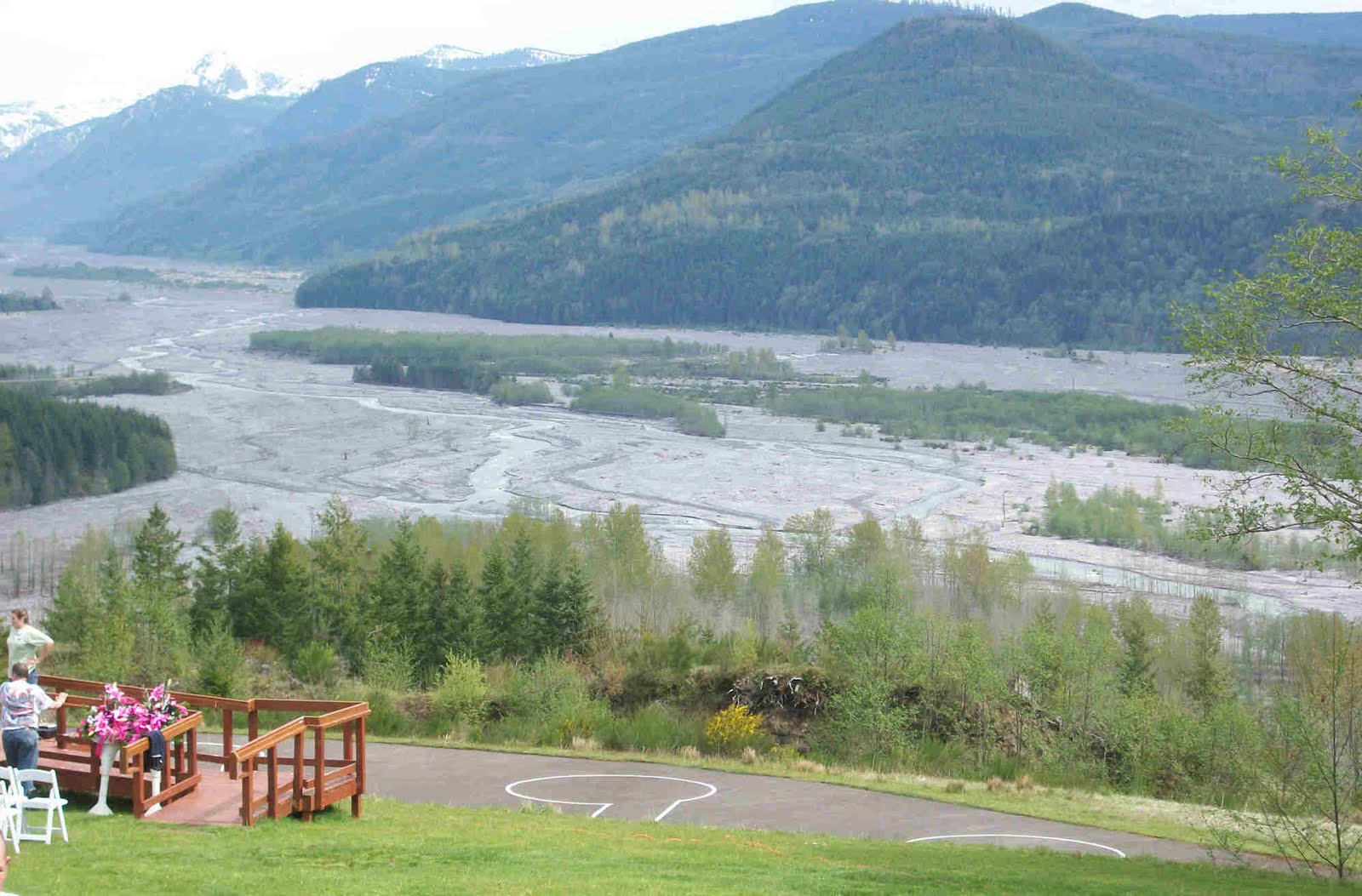
best view. This view shows where the avalanche occurred and below the Lehars flowed from left to right. 31 years of water have eroded the flow. We were five miles from the mountain.
Volunteers from the U.S. Geological Survey Volcano Hazards Program caught Fred’s eye where he tested their knowledge with lots of questions.


Amazing things happen here? In the last three decades few events have been more awesome than the growth of one of North America’s youngest glaciers in the throat of an active volcano. Behind the clouds inside the rim on the south side of the crater and in the shadow of the rim, snow accumulated year to year inside the great bowl. Year after year, snow accumulation exceeds melting by the remarkable amount of about 25’ on average forming the new glacier.


The real treasure of the Mount St. Helens National Volcanic Monument is not the volcano or the surrounding landscape; it lies in the idea that this monument should be protected so that nature can work at its own pace to renew the land. It was set aside in the hopes that the next generation will have an experience markedly different than the one we had today.


As we drove back down the mountain we could see the devastation still existing on the sides of the hills facing the explosion and the


result of the mud flow down the Touttle river.
The next stop on the way down was the Forest Learning Center where Olivia took a short flight over the new forests. When Mount St. Helens erupted, gale-force winds and intense heat flattened and burned 150,000 acres of prime public and private forests. During peak salvage efforts 600 log truck loads were removed daily.


Prior to reforestation, Weyerhaeuser recovered 850 million board feet of timber, enough wood to build 85,000 homes. Crews then hand planted more than 18 million Douglas and noble fir seedlings on Weyerhaeuser’s 45,500 acres.
We ended up staying in the National Monument about 4 hours. It was hard to comprehend the size of all these numbers of devastation that occurred in just a few hours, that day 31 years ago.
Sunday, May 15 we attended church at the


the Skamokawa United Methodist Church and challenged them to pronounce Waxahachie. We never mastered their name. It is a small church but warm and friendly. When we told them we had met Marge & Jerry, they knew them and had even seen them going to the cemetery earlier that week.
Back at the campground the fishing was on. Salmon were beginning to run upstream and the season started this day. The hosts had put up afishing tent at the end of the loop and we joined the group waiting. The technique is to bait the hook, then place the rod into a holder and attach a bell. They can then gather in the tent, with a wood heater and wait for the bell to ring. See the bell on the pole?
The bell rang and everyone came to life. Bob, the host, hadone on the line. The other fishermen reeled in their line and one grabbed a net. It is hard to pull in a fish over the riffraff rocks along the bank, so they went down the metal steps covering the rocks.
Bob played and worked the fish for about 10 minutes and had him almost to the steps, but it swam under the steps, breaking the line and it was gone. As you can see it was a nice size salmon. They estimated it at about 25 pounds. Too bad Bob. Later we were told salmon could be sold for $10 per pound at several of the local fish markets. Bob didn’t plan to sell his fish, but its interesting to note it had a value up to $300 dollars. Wow!


The fishermen re-baited their hooks and we waited again. After a while Bob gave up and we went home for supper. He had also told us about seeing an “Orka” whale this far up the river before. They are known to come up this far, but don’t stay long.


Periodically we could see a seal in the river. It was surprising to see them this far from sea water. The locals told us the story. Seal’s diet is primarily salmon. When the salmon enter the river for their spawning run some seals follow. Over the years the some seals have learned if they follow far enough (about another 100 more miles) they come to the Bonneville dam. At the base of the dam the salmon school and wait for a time before climbing the ladder over the dam. The seal love this. The waters are clogged with huge salmon waiting to climb the ladder. Sadly thousands of salmon are killed. Sadder still, the seals only eat the stomach and leave the rest. Fishermen are very upset over this carnage of their prized fish, but no solution is at hand.


Monday, May 16, we said our goodbye’s to the group at this wonderful spot. We hope we can go back to it sometime. We headed to I-5 north to Seattle. Immediately it was full of traffic going both ways.
Cheryl had told Olivia about Shipwreck Beads in Lacey so we just had to take a look. This business first location in 1969 was a tiny ship on Olympia’s Mud Bay. At 80,000 sq. feet it now has over 8.3 billion beads in stock. And they sell direct to the public in their


showroom or online at www.shipwreckbeads.com . It was a fun place to visit and Olivia covered every isle. The string of beads draped from the ceiling is in the Guinness Book of Records for the longest string of beads in the world.
Back on the road. When we reached Tacoma the pavement turned into washboard! Yikes! At first we didn’t know if it was the road or us! We were violently vibrating. Scary! In time the pavement changed for a short distance and we found it wasn’t us. Thank you God! We could not have stopped. No place to stop and lots of traffic. It was bad enough that it continued until our exit. Fred was exhausted!
We arrived at our destination and really wished we were back on the river. We were in an old RV park with permanent junkers around us. And it was pricey. If the Hensley’s had not been meeting us here we would have kept on going. Oh well, as Earl Spinks said many times, “You Win Some and Lose Some.” We have experienced both extremes of good and bad locations in the same week.

Tuesday, May 17 we went to the Microsoft Store and they gave Olivia some instructions on Word and Publisher. Olivia wished they had the stores all over. It was neat to be able to have a 15 minute tutorial in person. Then we went to the Chevrolet house to have our oil changed and check on few other items. We went back to Microsoft for some more instructions.


Wednesday, May 18 we went to a Doc-in-the-box Urgent care for Olivia to find out about her fingernail fungus and to receive a prescription for her dry eyes. We also attempted for Olivia to get her prescriptions filled, but it was too soon. We drove to the beautiful Lake Sammamish and the camp we had hope to stay in. Too bad they didn’t have vacancies for the whole week. The Hensley’s arrived and we made arrangements to see them the next day.


Thursday, May 19 we drove into downtown Seattle and met the Hensley’s at their hotel, then bought a greyhound bus tour for two days in the downtown seeing many interesting things including thestreet art. 10 % of improvements have to go to art work. We took the tour, then jumped off at Pikes’ Market where Fred interviewed the fish monger, we saw the expensive
Copper river King Salmon filets,big Halibut, and Fred drooled all around the Salmon and Halibut.
We watched them throwfish from the show room to the purchaser to be weighed, wrapped and sold.
We walked on through the market where we saw lots of beautiful flowers then on to the harbor where we ate chowder and fish & chips at Ivar’s. Olivia enjoyed feeding the our left over french fries to the sea gulls. We had thought we would ride the ferry to Bainbridge Island and back but time was running out, so we headed back to the hotel and watched part of the Maverick’s game. On our way back to the trailer park we could view Mt Rainier in the distance and over Washington Lake.


Friday, May 20 John was having brake problems so we met him at the Seattle Lexus. While we waited a lady stopped by and asked if we would like a tour of their facilities. We had already realized they had a big operation as it was a large three story building. She took us into the service area where they have 70 bays for working on vehicles. Most were occupied.
The next stop on her tour was the show room, which held at least 50 new cars. Adjacent to it was the delivery room with seven new cars waiting for their new parents. All this was enclosed because of the inclement weather in Seattle. Upstairs she showed us a snack bar and outside on the roof of the service entrance was a
three hole putting green.

Our guide who found we were from Texas told us their new dealer complex was inspired by a visit to the Sewell Lexus complex in Dallas. Does it have all this? We don’t know but maybe some of our readers do.
When John’s car was ready we left ours at the dealership and rode with John to pick up Virginia and drive out to Red Mill Burgers. Fred had seen this on Man vs. Food on the Travel Channel as a famous place to eat. Their most popular burger was a Bacon burger with cheese. Note the stack of bacon on the grill in the background! We ate outside on a picnic table as there was no room inside.
From there we drove to the Crittenden Locks and Gardens where we saw an Alaskan Yellow Cedar. It ranges all the way south to California. We had read an article about this tree and had been looking for it since Northern California. This was the first time we were sure we were seeing the real thing. It hasn’t been harvested like other trees, but now is being cut to make furniture.
We missed the salmon run at this river, but did see a Horse Hazelnut blooming.
It was getting late, but John decided we would visit the Boeing factory so we lit out for Everett. It was much further time wise than we thought and when we arrived the it was sold our for the day. Bummer! We did have some quality conversations in the car.
We were all tired so the Hensley’s returned us to our vehicle. We really enjoyed the Hensley’s company.


We visited the Microsoft Store again. This time we think we learned how to write these blog letters in Publisher before uploading them into the blog. Keep your fingers crossed.
We planned our attack on Canada and will stay at a city park in Lynden, WA where we would also receive our mail.

From Monday, May 22 we will not have cell service, and will only have emails via Wi-Fi hotspots and at Libraries.

Please answer us via email and we will attempt to answer you when we have a library.
In Alaska we expect spotty service for both cell and Wi-Fi.
We will continue to publish the blog for you to see what we are doing.

Please let us hear from you so email us at:
Olivia@bobheck.com or FredHarrington@yahoo.com