Monday, July 11 was a very hard day. We left the campground about 8:30 am, stopped in Glennallen for groceries, bought gas and headed to Tok following the Copper river, with

We made a stop to see an artists work of
 antler carving. Olivia had seen his work before and wanted Fred to see. Somewhere along the way we saw
 Trumpet Swans.
 We bought gas again in Tok and made a last effort in finding Fred a desired t-shirt, then headed on to the Deadman Lake Campground. This free campground is a part of the huge Tetlin National Wildlife Refuge. It had 15 sites and only 4 were taken including us. The only disadvantage was the temperature. It was HOT! And still. Not a breath of air. Well not hot by Texas standards, it was in the high seventies. Even though we were exhausted after driving 215 miles, we slept fitfully, with the windows open.
Tuesday, July 12 was another long day. About 25 miles down the road we entered the Yukon Territory of Canada. Our mileage that day was only 175 miles, but it was much worse. We had heard about this part of the Alaskan Highway from others, who did not take the Dawson/Chicken road as we did. Olivia was really dreading this road. More than 100 miles was
 either under construction or needed to be.
The Milepost tells, “Since the Alaska Highway was first punched through the wilderness in 10 short months in 1942, this war-time road has been under reconstruction. There never seems to be a shortage of road to straighten, culverts to fix, bridges to replace, or surfaces to level out...much of the soil is of glacial origin and unsuitable for road embankments. Anything that causes the permafrost to melt will cause the ice-rich soil to liquefy, and liquid soil has little strength and will settle or subside. Then if this soil refreezes during lower air temperatures, it will expand or heave. This process wreaks havoc on the drivability of the road surface by creating undulations and cracking.” “Travelers should watch for roadside flags indicating road damage, and slow down for bumps and dips.”
All of that is a major understatement!
Then there was construction and
 DUST!
DUST!
Fred rarely drove over 30 mph, because just as he gained that speed there was another problem to navigate around or through.
However between bumps, dips, dust and mud we did see some of the scenery. The
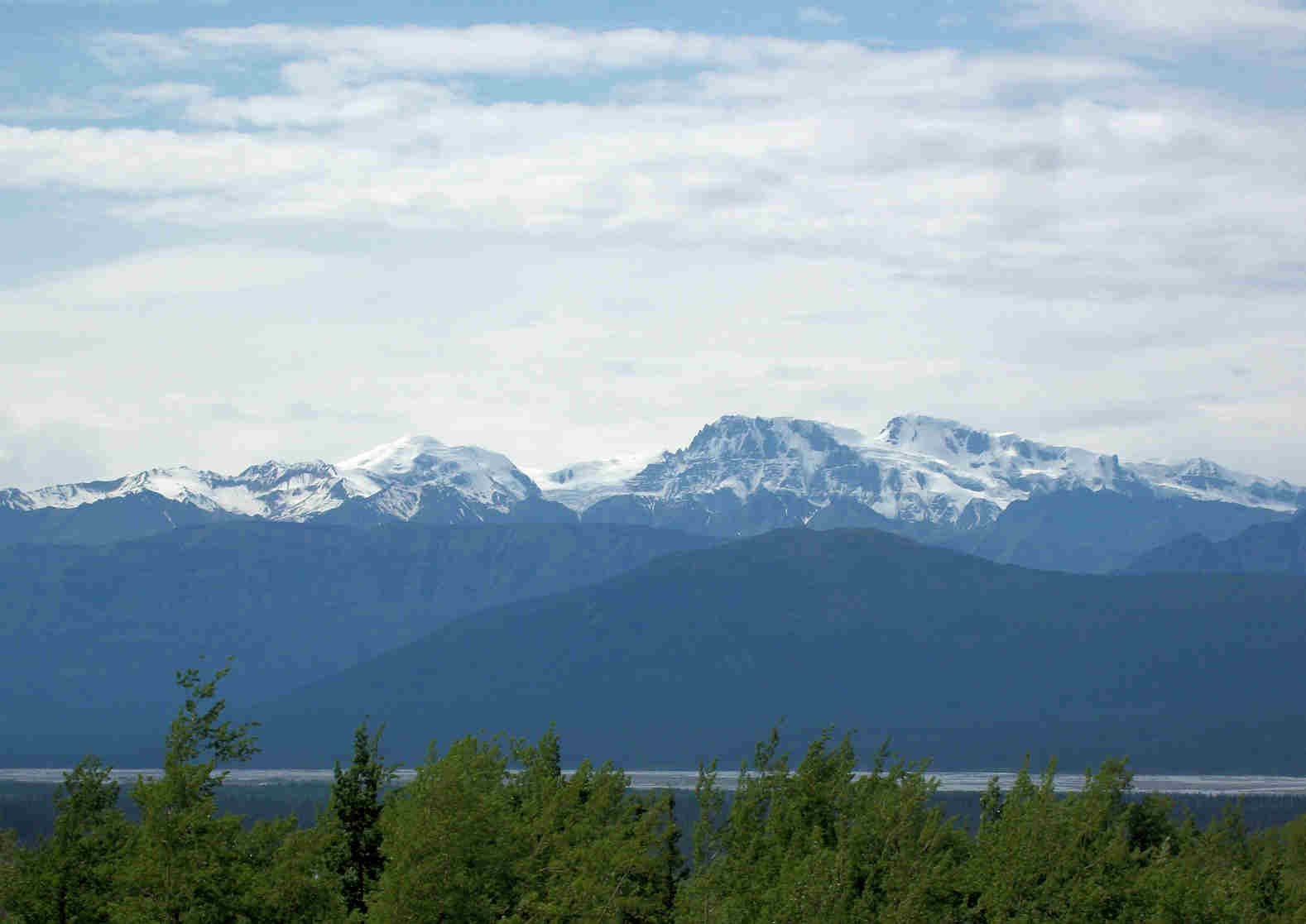 Icefield Ranges of the Elias Mountains were on the other side of the Donjek River Valley. These are the highest and youngest mountains in Canada.
To pass the time and distract us from the road we compared this 100 miles of this bad road to the 30 miles on the Top of the World road. Olivia thought the mileage comparison said a lot plus the scenery was much better on the TOW. The towns of Dawson and Chicken added to the atmosphere. The AK was much more intense with surprises every quarter mile or less.
We also reflected on our experience in Alaska. We were in the large part of Alaska for exactly one month, plus our time in Hyder and Skagway. We still had not seen a bear in AK. We did see eagles, porcupine, moose, swans, fox & coyote.
We passed the
 Kluane River valley with the Ruby Range in the background.
We were still experiencing rough road. It is hard to explain and even harder to take a picture. Each place was different. Sometimes even running down the road like an earthquake had
 split the road, then been repaired. Most of the road was built up 20’ or more off of the low unstable ground and still was bad.
Milepost had advertised The Chuckwagon, home of the best buffalo burgers. Fred’s mouth was drooling. It was about 10 miles past the bad roads. We drove on! But as we neared a sign read, “Closed.”
We were very glad to see a nice pull out with another trailer already stopped for the night. The
 Yukon Lupine were in full bloom between us and
 Kluane Lake with the
 Kluane Mountains in the background.
 fish ladder on the Yukon and Fred interrogated the young man working there. This is the only wooden fish ladder and it is a sloped ramp for the salmon to take to bypass the dam.
 view of the canyon, now part of their lake.
 Yukon Lupine were in full bloom between us and
 Kluane Lake with the
 Kluane Mountains in the background.
We visited with the couple from Alabama before retiring for the night. It was nice to hear the southern accent as we chatted with them of roads traveled and to travel.
Wednesday, July 13, we drove into Haines Junction and attempted to find out about a place on Olivia’s leg. She thought it was a mosquito bite at first, then maybe poison ivy or a spider bite. The clinic in Haines Junction, Yukon Territory, said it would be $550 just to be seen. Over $500 for an office visit! We called the insurance to see if she was covered and it was $250 deductible in Canada. She had been putting a powerful medicine on it for poison ivy or other rashes. We were mainly concerned if it was a brown recluse spider.
We also debated as to whether to go to Haines, AK to see the drive down there, but if so we would take a ferry over to Skagway and take that drive back into Canada. We decided to go onto Whitehorse and watch the rash. We found our old place on Wal-Mart’s parking lot, checked messages at the library, and ate fish & chips. We were so tired we went to bed at 7:30 pm.
Thursday, July 14, we decided to stay another day in Whitehorse, so we took it easy. Exploring we found the
 fish ladder on the Yukon and Fred interrogated the young man working there. This is the only wooden fish ladder and it is a sloped ramp for the salmon to take to bypass the dam.
We were told this area is 1200 miles down the Yukon to salt water, Only the king salmon is strong enough to make this spawning run. It takes over two months to make the trip. A king will lose up to 75% of its body weight on the trip. After hatching the smelt spend one year near their birth area and one year working their way down stream to the Bering Sea.
We followed the Miles River road on the opposite side of the river and found a bluff to get a
 view of the canyon, now part of their lake.
When the stampeders with their hand-built boats and rafts, congregated at the head of Miles Canyon and White Horse Rapids, they needed a pilot
 to navigate the rapids. Their goods were shipped around the rapids on a tramway. The walls of the canyon are overlapping flows of basalt lava cooled in the Yukon River about 8.5 million years ago. As the lava cooled, it created
 five or six-sided columns that cracked. The river rushed over the basalt and worked away at the cracks to erode the rock and form the canyon.
 filling up with rigs. We were beginning to think their local customers wouldn’t have a place to park. We counted 39 rigs at that time. Later we saw some come and some go. This is truly a revolving door. We met a man from Prince George and a brave lady from Florida traveling alone in a pick up camper.
 General Store which claims to be the oldest store in the Yukon. It did have unique items for sale.
Saturday, July 16 was a very long day. We headed back to the Alaska Highway stopping at Johnson Crossing for their famous cinnamon buns. They were out! He had another batch in the oven so we waited 15 minutes for them to come out hot. He put extra icing on one for us to eat for our lunch. Delicious. Much better than the one we had somewhere else that was a big bread. This man sells around 150 a day @ $3.15 each. There were 8 on the pan he took out of the oven for us. We took another to go for another time.
 to navigate the rapids. Their goods were shipped around the rapids on a tramway. The walls of the canyon are overlapping flows of basalt lava cooled in the Yukon River about 8.5 million years ago. As the lava cooled, it created
 five or six-sided columns that cracked. The river rushed over the basalt and worked away at the cracks to erode the rock and form the canyon.
The rapids formed the white for Whitehorse as the early settlers said it looked like white horses manes in the water, therefore calling this Whitehorse.
The area is surrounded by white bluffs created by glaciation about 20,000 years ago. As the ice sheet melted, thick deposits of white silt, sand, and gravel were left in the valley bottom, covering the bedrock and forming the rolling hills that surround Whitehorse.
By 5:00 pm the Wal-Mart parking lot was
 filling up with rigs. We were beginning to think their local customers wouldn’t have a place to park. We counted 39 rigs at that time. Later we saw some come and some go. This is truly a revolving door. We met a man from Prince George and a brave lady from Florida traveling alone in a pick up camper.
Friday, July 15 instead of driving on the Alaska Hwy toward Watson Lake, we decided to drive to Carcross, park the trailer and drive on to Skagway and visit their clinic. The place on Olivia’s leg had not improved and this was our last chance to get US Medicare & insurance as we would be in Canada another two weeks.
It was raining, but the closer to the border the lighter the sky. By Skagway the sun was out. We were able to get into the clinic within 30 minutes of arriving. We saw an advance nurse practitioner. After consulting her book she told us it was similar to poison ivy which does not grow up here. There were three possibilities of plants she had touched: devil’s club, nettle, or cow parsnip. We know what the last two look like, but not devil’s club. We will have to research it to see what it looks like. Olivia was given a dose pack to take over the next six days. Hopefully it will take care of it. Total cost was insurance paid, except $10 for the medication.
We tried again to find the Alaskan t-shirt Fred wanted, but were not successful.
The coastline of this part of Alaska down to the Seattle area is Tingit (Klink-it) Indian territory. They build totem poles and favor the wolf, eagle, bear & fish symbols.
Arriving back in Carcross we drove through the town and visited the
 General Store which claims to be the oldest store in the Yukon. It did have unique items for sale.
Saturday, July 16 was a very long day. We headed back to the Alaska Highway stopping at Johnson Crossing for their famous cinnamon buns. They were out! He had another batch in the oven so we waited 15 minutes for them to come out hot. He put extra icing on one for us to eat for our lunch. Delicious. Much better than the one we had somewhere else that was a big bread. This man sells around 150 a day @ $3.15 each. There were 8 on the pan he took out of the oven for us. We took another to go for another time.
Most of the day was spent driving. There was lots of
 rock graffiti along the road. Olivia commented it was a nice way to make their mark and nothing was hurt.
 rock graffiti along the road. Olivia commented it was a nice way to make their mark and nothing was hurt.
We finally reached Watson Lake and went directly to the visitor center to see their video, get road information, then to wander through the sign post forest. We spent about 30 minutes reading
 signs but did not find Waxahachie. Too bad, we should have gone to the city and acquired a sign to put up. We really thought Beverly’s groups had been here and placed one. It might have been there as we didn’t go down all of the rows, since there were over 73,000 signs, but we did see:
 two young bears, probably siblings even though one was brown the other black. When Fred first stopped they were grazing down the hill, then
 started playing, now
 dancing, then
 back to business.
 signs but did not find Waxahachie. Too bad, we should have gone to the city and acquired a sign to put up. We really thought Beverly’s groups had been here and placed one. It might have been there as we didn’t go down all of the rows, since there were over 73,000 signs, but we did see:
Alamo, Arlington, Beasley, Blessing, Bluff Dale, Borger, Bridge City, Brownwood, Canton, Clyde, Corpus Christi, Corsicana, Dallas, Denton, Emery, Fannett, Fort Worth, Glen Rose, Gothwaite, Harlingen, Haskell, Hull, Ingram, Jasper, Justin, Kerrville, Kilgore, Lake Jackson, Leakey, Lampasas, League City, Leon Springs, Lubbock, Lumberton, Margaret, Marion, Pasadena, Plano, Pleasanton, Port Aransas, Port Arthur, Proctor, Robstown, San Angelo, San Antonio, San Saba, Sandia, Sherman, Silsbee, Sugar Land, Texline, Valley View, Van Rickley, and Weatherford.
We did find out the Alaska Highway is open year round which is amazing! So many miles and miles to keep open in the winter. Must be some powerful snow plows.
After supper of buffalo burgers we attended the Northern Lights theater where we watched a show about astronauts in outer space. It showed all the affects weightlessness caused the human body. The second show was about the Northern Lights, what caused them and how they looked.
By this time it was 7:30 pm, we bought gas and headed out of town for a pull out on the highway. By morning there were two others who had spent the night there also.
Sunday, July 17, another Sunday without a church to attend. We headed south and east following the Laird River, when we could see it. The highlight of our drive was spotting
Sunday, July 17, another Sunday without a church to attend. We headed south and east following the Laird River, when we could see it. The highlight of our drive was spotting
 two young bears, probably siblings even though one was brown the other black. When Fred first stopped they were grazing down the hill, then
 started playing, now
 dancing, then
 back to business.
A few more miles down the road a huge  bull bison was sauntering down the shoulder of the road. Fred slowed, Olivia rolled down the window and shot as we passed. We did see two other bears and five other bison, but these were our best shots.
 bull bison was sauntering down the shoulder of the road. Fred slowed, Olivia rolled down the window and shot as we passed. We did see two other bears and five other bison, but these were our best shots.
Our destination for the day was the Laird Hot Springs. This was high on the recommendation list from other travelers including Edward and Jeanette that we met on the Mississippi River in Wisconsin. They have not been wrong on their recommendations so this spot was highlighted on our map. We pulled in about noon and found plenty of campsites to choose from. After setting up we walked back to pay, then on to look over the
 hot springs. It looked just like the pictures. We inquired where the hottest spots were and more important where the cooler spots could be found. It was reported that the closer end could get up to 126 degrees! Ouch! Olivia stepped down to test it out and the 2nd steps. It didn’t burn, but was close to it. The steps in the background had the best temperature. We planned to go back after supper when the outside temperature would be cooler.
 Louise, Olivia and Rudolph entered there and slowly went further down stream. Fred stayed on dry land to take pictures and preserve his hearing aids. Even though the sign said there was a sulfur smell it didn’t smell like the sulfur water at Glen Rose. Phew!
A young man in the
 group said his grandmother came each year for a week and bathed three times a day in the springs and her arthritis would go away.
 whole herd of bison didn’t take a lot of vision. Then there was another
 herd crossing the road.
 hot springs. It looked just like the pictures. We inquired where the hottest spots were and more important where the cooler spots could be found. It was reported that the closer end could get up to 126 degrees! Ouch! Olivia stepped down to test it out and the 2nd steps. It didn’t burn, but was close to it. The steps in the background had the best temperature. We planned to go back after supper when the outside temperature would be cooler.
On our way back to the campground we met a couple from New Zealand who were seeing BC in a traded RV. They had swapped with a couple in Canada and were here for six weeks. We invited them to our site for a visit and get acquainted. They were so much fun we went together to the hot springs after supper.
Since Olivia had tested the water in the afternoon and knew it was cooler downstream.
 Louise, Olivia and Rudolph entered there and slowly went further down stream. Fred stayed on dry land to take pictures and preserve his hearing aids. Even though the sign said there was a sulfur smell it didn’t smell like the sulfur water at Glen Rose. Phew!
A young man in the
 group said his grandmother came each year for a week and bathed three times a day in the springs and her arthritis would go away.
Louise & Rudolph were so interesting. They had immigrated from Holland to New Zealand 42 years ago and were given family benefits along with his job to be able to survive. He worked for the National Park Service. They have had boats and sailed from New Zealand to Fiji. They love the World Cup and hope to attend the next one in San Francisco.
Monday, July 18, we agreed to travel along with Louise & Rudolph and they were great at spotting wildlife. Of course a
 whole herd of bison didn’t take a lot of vision. Then there was another
 herd crossing the road.
The scenery was very nice as we entered the north end of the Rocky Mountains. Muncho Lake was so pretty with
 multi-colors of blue and green.
 The drive along Muncho lake was so nice. Then we saw a moose and after she relaxed she knelt down for a
  drink of water.
A shedding
 reindeer was next on our list of wild life before we saw
  “Folded Mountain.”
We turned up a
 rocky limestone gorge watching for more wild life and we were in luck by seeing a
 stone sheep. She is hard to see in the picture because of her camouflage.
We found a pullout for the night and enjoyed the company for tortilla soup. As we were preparing for bed a trucker stopped and informed us there was a $2500 fine for spending the night in a break check pullout. So we hurriedly picked up and moved down the road. What a hassle! We wished we had known and not stopped there at all. True or not we won't chose one of those pull outs again.
This ends this chapter as we enter Ft Nelson, still way up north! We stopped and washed the trailer then pulled into an RV park for the night to charge up and post this blog.
This ends this chapter as we enter Ft Nelson, still way up north! We stopped and washed the trailer then pulled into an RV park for the night to charge up and post this blog.
FYI: Olivia's leg is ok now. Guess the hot springs cured it! Of course the medicine really did the trick.
We love to hear from you, and your comments about this letter as well as news from home so email us by clicking on
Olivia@bobheck.com or FredHarrington@yahoo.com
We love to hear from you, and your comments about this letter as well as news from home so email us by clicking on
Olivia@bobheck.com or FredHarrington@yahoo.com


 Portage Glacier, but we did see several


 Denali, there it was peaking out from behind the trees. We kept getting glimpses until we stopped at a roadside park designated a viewing site. By then a little cloud came in front of it and everyone, including us just sat and waited for the cloud to go away.

 Susitna River and saw people down on the bank. We decided to head back to that spot later to spend the night. When we parked it was after 5:00 pm and we were hot and tired. Yes , hot it was 71 degrees today and felt hot compared to what we have had weather-wise. Shortly after parking and opening the windows a nice breeze sprang up and it was delightful.


 mountains and over hills.
 big cleared area where hunters and ATV’s park to enjoy the country to the north. The trail leads over the hills behind us. The best part about this spot was the view across the road to the south. We could see the


 bicycles riding to Valdez on their 400 mile ride. We saw them going and coming.
 holding this 48” diameter pipeline which winds through 3 major mountain ranges and terminates in Valdez.


 rolling over the top like an avalanche.
 to the valley of Valdez and the

 Bridal Veil and


 fishing all along, under the mountains.


 bicycler’s laboring over the big climb. Too bad they weren’t looking at the
 fireweed is among the prettiest of the wildflowers in the north country. We have enjoyed it every time we go north of the 45th parallel. The story is when it quits blooming winter is six weeks away.