 smell and see the smoke.
We were told the first day the fire consumed 6,000 hectares, yesterday 600,000 hectares.
We did enjoy the beautiful drive, what we could see through the smoke and clouds. Sometimes there were lakes or rivers on both sides. We did stop at Jade City for a pit stop and admired all the jade
 inside and out. It was pretty and expensive.
At Good Hope Lake we bought the
 most expensive gas so far. We certainly hope it goes down from here, but this was a very remote area and they got away with $6.36 a gallon.
Finally we arrived at the barricade only 40 miles south of the Alaska Highway. Before long there were other RV’s and a few cars behind us. Soon we were all
 out visiting with each others. We discovered Swiss, German, Connecticut, Texan and Whitehorse represented in this cluster. We visited with the man on the barricade and he told us he had been called by a friend to fill in on his job as a snowplow driver all winter, then he stayed on. Not only was he paid a salary, but his boots and heavy coat, dorm, and isolation pay were included.
After a two hour delay we were the lead rig after the pilot car. After several miles we entered the
 burn area. From what we could tell this burn was about six miles along the highway. No telling how far it went both ways. Most of the fire was gone, but
 occasionally we saw smoke from a stump.
As we completed the new burn we entered an old burn and we went through it for
 15 more miles. It was sad, but we know it is best for the forest to restore itself.
All the way through this controlled area was the north end of the Cassiar Highway. The pilot car drove the speed limit and we felt compelled to keep up with him as there were others behind us. The road was not as good as the southern part of the Cassiar. It was a little narrower, with no shoulder, but paved 99.9% paved. The scenery was definitely worth it.
 We did see eight bears, one moose, 33 cars and 4 motorcycles today.
All total that makes 22 bears, 1 moose, 68 cars and 4 motorcycles we have met in over 450 miles of the Cassiar. It was nice to have the road to ourselves.
Now we turned north on the Alaska Highway with its wide lanes, big shoulders made us feel like we were on a freeway. But along with the extra good road came the cars, RV’s, trucks and 18 wheelers.
It wasn’t long before we found a big pullout well off the road and settled in for the night.
 Saturday, June 4 we drove north on the Alaska Highway, stopping in Teslin to view the longest
 water span on this highway. This bridge had metal grated decking which made the car and trailer drift. It was a weird and scary crossing. On the other side of Teslin we stopped at the Tlingit Heritage Center, where we ran into Guy from the Glacier View campground a few days ago. It was neat to see him again. The Center was a disappointment. We had been told to eat at Muckaluck Annies, but she wasn’t open for the season yet. Then Olivia was distracted and we missed the famous cinnamon buns at Johnson’s Crossing. Oh well, we will be traveling this stretch of the Alaska Highway on our way back. One of our few resteps we plan to take.
At Jake’s Corner we turned west on a shortcut to Carcross. We could see the
 Montana Mountains from this road.
 Montana Mountains from this road.
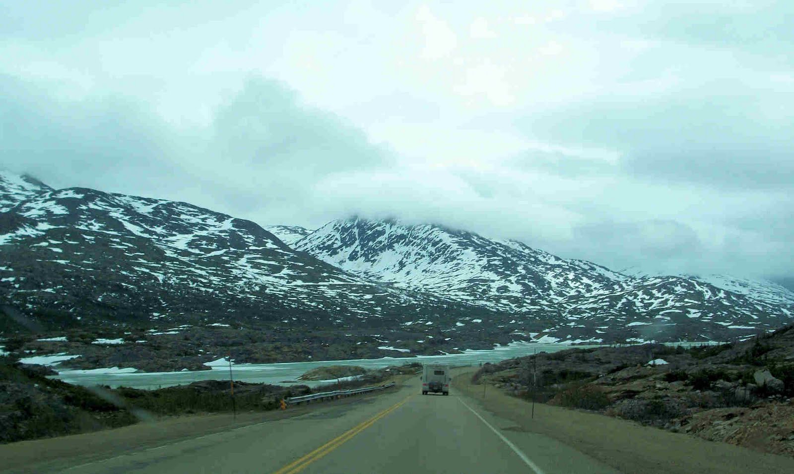
Turning south on the South Klondike Highway we saw
 Lime Mountain which seemed surreal with the bare rocks. This highway led us passed
 Windy Arm of the Tagish Lake to the border back into British Columbia. Another beautiful
 Tutshi Lake for ten miles. This was a
  beautiful drive. Then we followed the with the bonus of seeing
 two bears along the way. We climbed through tundra to the frozen
 Bernard Lake and the top of White Pass and the Alaskan border, Inuits
 were built all around this stop.
Then OH, MY GOD WHAT YOU HAVE CREATED!
 Thank you so much for allowing us to see this beautiful country. The drive took us eleven miles down a steep descent to Skagway with 11 percent grade. The pictures speak louder than words.
 At the top of the pass looking south
 A little further down
 Looking back
Looking south
 See the train

Thousands of gold seekers poured into Canada over the Chilkoot and White passes on their way to Dawson City after debarking in Skagway. The Superintendent of the Canadian Government, Samuel Steele, finding thousands of men waiting to pack their supplies over the pass. He immediately stationed permanent detachments at the summits of Chilkoot and White passes, both to maintain law and order and to assert Canadian sovereignty at these two international borders. After witnessing the desperate condition of many men arriving in the Klondike, Steele set a minimum requirement of a year’s supply of food and equipment—”one ton of goods”—for any miner entering Canada. Can you imagine carrying 2,000 # of goods over these mountains, then 600 more miles to the gold fields? The first order was to get your supplies over the pass. This was done in increments of 50-100 pounds which meant trip after trip up the mountain loaded and down the mountain empty. For most it took 30 days to accomplish.
Sunday June 5 we were up early and walked to the docks to catch the Fjord Express to Juneau. It headed south through Lynn Canal, our continent’s longest and deepest glacial fjord. We didn’t know we had any fjord’s in the USA, but here we were, on one.
 Lime Mountain which seemed surreal with the bare rocks. This highway led us passed
 Windy Arm of the Tagish Lake to the border back into British Columbia. Another beautiful
 Tutshi Lake for ten miles. This was a beautiful drive. Then we followed the with the bonus of seeing
 two bears along the way. We climbed through tundra to the frozen
 Bernard Lake and the top of White Pass and the Alaskan border, Inuits
 were built all around this stop.
Then OH, MY GOD WHAT YOU HAVE CREATED!
 Thank you so much for allowing us to see this beautiful country. The drive took us eleven miles down a steep descent to Skagway with 11 percent grade. The pictures speak louder than words.
 At the top of the pass looking south
 A little further down
 Looking back
Looking south
 See the train

Thousands of gold seekers poured into Canada over the Chilkoot and White passes on their way to Dawson City after debarking in Skagway. The Superintendent of the Canadian Government, Samuel Steele, finding thousands of men waiting to pack their supplies over the pass. He immediately stationed permanent detachments at the summits of Chilkoot and White passes, both to maintain law and order and to assert Canadian sovereignty at these two international borders. After witnessing the desperate condition of many men arriving in the Klondike, Steele set a minimum requirement of a year’s supply of food and equipment—”one ton of goods”—for any miner entering Canada. Can you imagine carrying 2,000 # of goods over these mountains, then 600 more miles to the gold fields? The first order was to get your supplies over the pass. This was done in increments of 50-100 pounds which meant trip after trip up the mountain loaded and down the mountain empty. For most it took 30 days to accomplish.
Sunday June 5 we were up early and walked to the docks to catch the Fjord Express to Juneau. It headed south through Lynn Canal, our continent’s longest and deepest glacial fjord. We didn’t know we had any fjord’s in the USA, but here we were, on one.
The new 65’, fast-hulled catamaran was specially designed for the waters of Lynn Canal. The
captain had gone to southern California and watched it being built to his specifications, then brought it home, taking three weeks along the coast. It was comfortable with 360 degree views. Olivia never did get her sea legs, and wobbled all over the ship to get pictures.
Before we reached Haines to pick up two more passengers, our  captain and his first mate pointed out
 Bear Cave falls . When we arrived in the
  harbor at Haines,an
 eagle was watching us.
Not too far down the fjord we pulled over to watch
 sea lions resting on the rocks and one bull had the audacity to mate while we watched. We were told the female conceives next years pups, while pregnant with this years pup.
As we traveled down the Lynn Canal the
 Chilkoot
 and Coastal mountains to the west were gorgeous. It was “world class scenery.” We saw a few
 whales, then passed an
 eagle rookery where there were at least 100 birds along the shore. There are at least 14 in the above pictures. Dan you find them? Young birds do not have the white feathers.
When asked about the the eagles staying low to the water, we were told there were herring in the waters. They were ready to feed.
captain and his first mate pointed out
 Bear Cave falls . When we arrived in the harbor at Haines,an
 eagle was watching us.
Not too far down the fjord we pulled over to watch
 sea lions resting on the rocks and one bull had the audacity to mate while we watched. We were told the female conceives next years pups, while pregnant with this years pup.
As we traveled down the Lynn Canal the
 Chilkoot
 and Coastal mountains to the west were gorgeous. It was “world class scenery.” We saw a few
 whales, then passed an
 eagle rookery where there were at least 100 birds along the shore. There are at least 14 in the above pictures. Dan you find them? Young birds do not have the white feathers.
When asked about the the eagles staying low to the water, we were told there were herring in the waters. They were ready to feed.
We arrived at the small harbor north of Juneau and were picked up by a Gray Line bus and were driven the 30 miles into the city of
 Juneau.
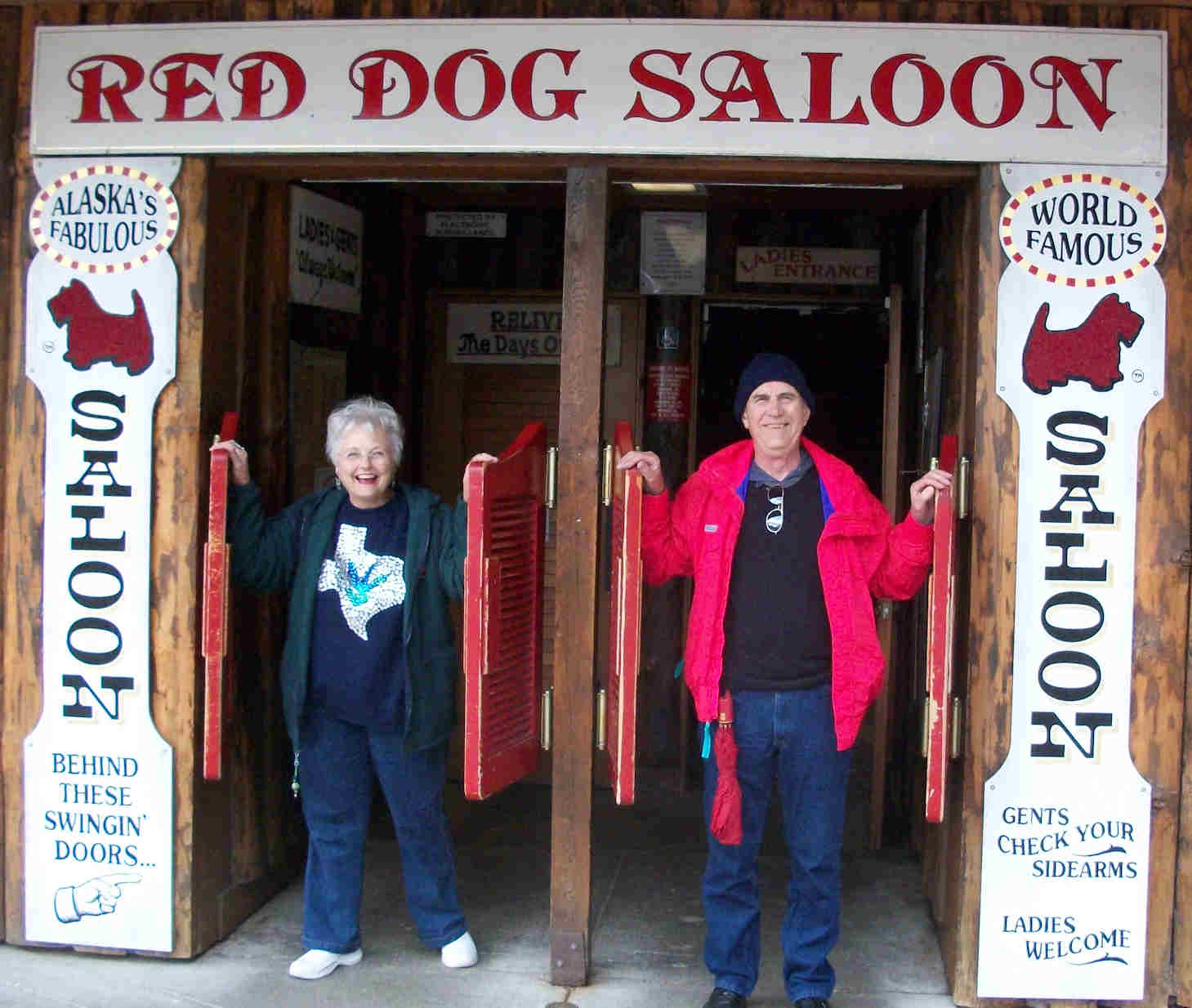
We ate lunch, then walked the streets being greeted by a huge
 teddy bear then enjoyed posing at the
 Red Dog Saloon.
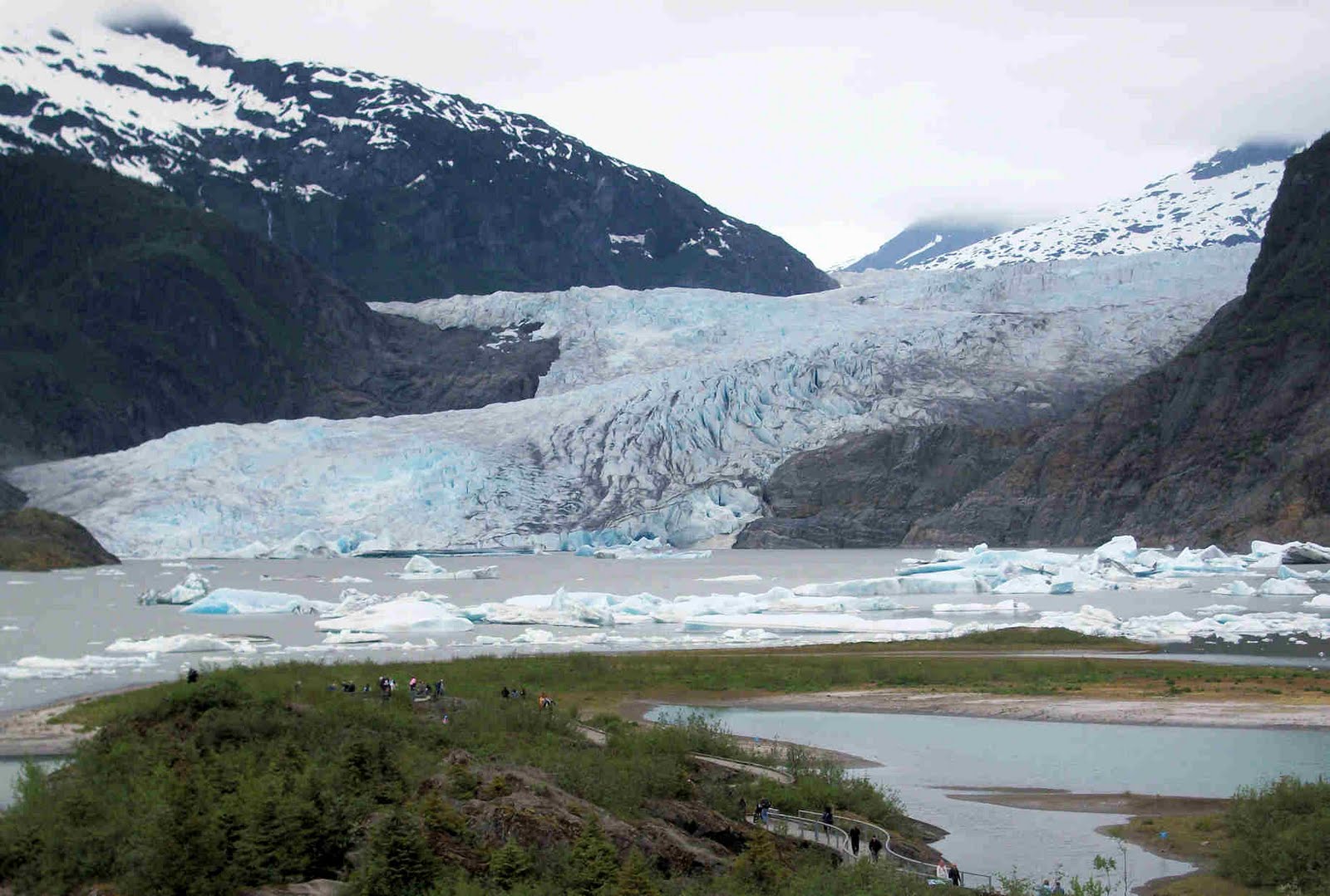
Our bus driver pointed out all the sites along the route to the
 Mendenhall glacier where we enjoyed the movie and Fred picking the rangers mind about glaciers. He learned there is no minimum size for moving ice to be called a glacier, it must be at least 60 meters thick. So, in effect, an ice flow must be rather large to called a glacier.
The bus driver told us the schools had fences around the playgrounds to keep the bears out and the children safe. Different twist to fences around schools.
 Juneau.
We ate lunch, then walked the streets being greeted by a huge
 teddy bear then enjoyed posing at the
 Red Dog Saloon.
Our bus driver pointed out all the sites along the route to the
 Mendenhall glacier where we enjoyed the movie and Fred picking the rangers mind about glaciers. He learned there is no minimum size for moving ice to be called a glacier, it must be at least 60 meters thick. So, in effect, an ice flow must be rather large to called a glacier.
The bus driver told us the schools had fences around the playgrounds to keep the bears out and the children safe. Different twist to fences around schools.
Back to the Fjord Express for out trip back we enjoyed the way the
 captain steered the boat. The
 inland passage and coastal mountains were clear and beautiful.
We were steered near the historic
 Elred Rock lighthouse, which is for sale, where we saw more eagles and on the north side we saw seals playing in the water along with a
 sea otter. What a nice surprise.
Monday, June 6, Happy Birthday Patti! We spent the day in Skagway starting with a walking tour of town. Olivia
 posed in front of Olivia’s restaurant. At the national park visitor’s center we learned the whole town was a national park and the story of the stampeeders. Once the major Klondike gateway, Skagway still boasts many historic Gold Rush buildings. GOLD! GOLD! GOLD! GOLD! Was the headlines in US papers and they came. They were required to carry a
 ton of food and goods over the pass into Canada so they would not starve and would have the supplies they needed for a year.
We saw this
 picture of them with their gear as they started across the coastal mountain to the Yukon River headwaters enroute to Dawson City, Canada and the goldfields.
And this picture of them climbing the 
Chilkoot pass. If they stepped out to rest, they would have to wait as much as two hours to get back in line. These fabled Golden Stairs humbled Argonauts intent on the summit. This vivid image—and endless line of prospectors toting enormous loads like worker ants—became the Klondike Gold Rush icon. It took three months and 20-40 trips to carry their ton of goods over the pass.
Our ranger guide was passionate about the story of the stamped and told us about
 Soapy Smith and his conmen and how their criminal activities taking advantage of the stampeders.
The
 Artic Brotherhood Hall is now the town’s visitor center with it’s façade made of twigs from driftwood. In less than two years in 1899, a local ordinance required boardwalks on both sides of Broadway and brick chimneys.
The afternoon was spent driving over to the deserted town of Dyea where some of the stampeders departed for the Chilroot pass. On our way back we overlooked
 Skagway. Then Olivia and Fred drove back up the White Pass to look at the mountains and enjoy the mileage without the trailer. We did not ride the train as we could see most of its route from the car.
Tuesday June 7 we left Skagway with a beautiful clear blue sky. At the top of
 White Pass we enjoyed the mountains and frozen lake again.
Next we saw many
 reflections of mountains and clouds in the lakes we followed.
After visiting Carcross we saw
 two bears, but only one posed for us.
This ends Letter 11. We hope you enjoy it.
For comments and nates to us, please email us at
Olivia@bobheck.com or
Fredharrington@yahoo.com

Chilkoot pass. If they stepped out to rest, they would have to wait as much as two hours to get back in line. These fabled Golden Stairs humbled Argonauts intent on the summit. This vivid image—and endless line of prospectors toting enormous loads like worker ants—became the Klondike Gold Rush icon. It took three months and 20-40 trips to carry their ton of goods over
the pass.
Our ranger guide was passionate about the story of the stamped and told us about
 Soapy Smith and his conmen and how their criminal activities taking advantage of the stampeders.
The
 Artic Brotherhood Hall is now the town’s visitor center with it’s façade made of twigs from driftwood. In less than two years in 1899, a local ordinance required boardwalks on both sides of Broadway and brick chimneys.
The afternoon was spent driving over to the deserted town of Dyea where some of the stampeders departed for the Chilroot pass. On our way back we overlooked
 Skagway. Then Olivia and Fred drove back up the White Pass to look at the mountains and enjoy the mileage without the trailer. We did not ride the train as we could see most of its route from the car.
Tuesday June 7 we left Skagway with a beautiful clear blue sky. At the top of
 White Pass we enjoyed the mountains and frozen lake again.
Next we saw many
 reflections of mountains and clouds in the lakes we followed.
After visiting Carcross we saw
 two bears, but only one posed for us.
 This ends Letter 11. We hope you enjoy it.
For comments and nates to us, please email us at
Olivia@bobheck.com or
Fredharrington@yahoo.com
Glad you found Willard! Great pics and posts! Mike recognized the bridge that we crossed on our Alaska trip last summer! :)
ReplyDelete